Project Overview
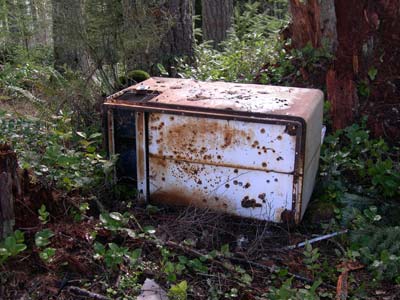
Photo: courtesy of Mark Neff
Illegal Dumping:
"Illegal dumping is disposal of waste in an non-permitted area."
- Despite potential fines and prosecution, illegal dumping in Lane County remains a large problem. Presumably, illegal dumping can result from such factors as:
- Environmental Protection Agency's Illegal Dumping Prevention Guidebook
- Fees: For many items, there are costs associated with dumping at transfer stations. These items include, but are not limited to, tires, appliances and hazardous materials.
- Limited hours: The operational hours of transfer stations or landfills may not correspond with many peoples' schedules.
- Vicinity: Transfer stations are not necessarily evenly distributed throughout the county. Long driving distances to legal dumping facilities can contribute to illegal activity. Similarly, short driving distances to convenient dumping areas, such as nearby forestlands, can also increase the likelihood of illegal dumping.
Our Client - The Bureau of Land Management
- We are working in coordination with the Oregon/Washington Bureau of Land Management. This local BLM division is interested in determining the effectiveness of their current clean-up programs for illegal dumping in Lane County. This is where we our team steps in.
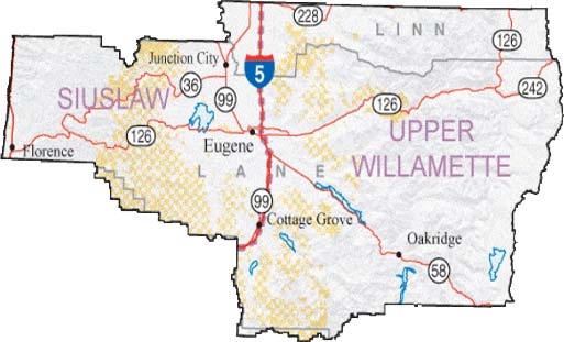
- The above map shows the amount of land - approximately 10%, signified by light orange - that is managed by the BLM in Lane County. The county is split into two regions: the Siuslaw and Upper Willamette. To see maps showing where our project is focused, go to our "Findings" page.
Illegal Dumping in Lane County
Initial Clean-up
- In 2001, the local BLM division initiated a massive clean-up effort to restore the areas of Lane County most affected by illegally dumped waste. The focus of this endeavor was in the foothills only on the eastern side of Interstate 5. The BLM's program is interested in making these natural areas clean, healthy, safe and usable for everyone.
Regular Patrols Established
- After this first cleaning sweep, the BLM divided Lane County, east of Interstate-5, into six illegal dumping zones. Regular patrol routes were established by determining which areas seemed to have the most illegal dumping activity. The routes traverse through a limited portion of a very expansive network of mostly decomissioned logging roads, which allow illegal dumpers access to nearly every nook and cranny of the Willamette Valley foothills. These established routes are patrolled regularly by the county Youth Services Forest Clean-up Crew, and the BLM has been working dilligently to combat illegal dumping. A map showing regular patrol routes in our study area - the Mohawk River Valley - can be accessed in our "Findings" section.
Illegal Dumping West of I-5
- Recently, during a survey of marbled murrelets (a coastal bird which utilizes both marine and forest ecosystems) in the BLM lands west of I-5, a biological survey crew obtained additional illegal dumping data. The survey crew could only observe the marbled murrelets during the early hours of the morning, so remaining workhours were spent finding and recording illegal dumpsites. This data will be used in conjunction with the data we obtained in the Mohawk Valley to determine whether certain environmental conditions (e.g. dead-end roads, steep embankments, proximity to main roads, etc.) facilitate illegal dumping activity. In this way, the BLM will be able to make educated decisions when planning clean-up patrol routes in the forest lands west of I-5. To see a map of this data, go to our "Findings" page.
Our Project Goals
Dumpsite database: www.dumperstumper.com (online May 15, 2005)
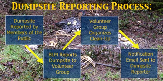
- In mid-May we will be uploading an illegal dumping database which will contain information for individual dumpsites that have been located in Lane County. As can be seen in the above flow-chart, the public will notify the BLM and volunteer group(s) of illegal dumpsites by reporting dumpsite location, estimated size, and composition, among other characteristics. By allowing individuals access to this database, we will be involving the public in the important responsibility of keeping our forests and watersheds clean and healthy.
Maps and Graphs
- In addition to www.dumperstumper.com, we will also be producing a series of maps and graphs to show our data and analyses using GIS (Geographical Information Systems/Software). Our data was gathered through an extensive inventory of dumpsites within Block 1 of the BLM trash blocks (the Mohawk River Valley). Using a Trimble GPS data logger (pictured below) on loan from the BLM, we located a total of 148 dumpsites during our 50 hours of data collection.

- Besides showing dumpsite locations, the maps will be conveying such things as severity of dumpsites, approximate dumpsite size, proximity to geographical features (dead-ends, signs, gates, etc.), and "hot-spots" for illegal dumping activity. We will also be producing a similar set of charts and graphs showing much of the same data. These analyses can be accessed in our "Findings" page.
New Developments
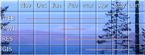
- As the above timeline shows, while a fair amount of our project tasks have been completed, important developments are coming soon:
- WEB: Wade has been designing our database since last October; it will be available by mid-May.
- MWI: The Mohawk Watershed Inventory - the gathering of dumpsite data in the Mohawk Valley - has been completed and the data is being processed.
- RES: Since January we have been researching various aspects of illegal dumping. This will all be included in our final report, to be completed in June.
- GIS: This map-making component of the project began in March, and will continue until June.
