 |
 |
||||||||||
|
These images are from a studio project where the author used many photos and site walk through sequences in conjunction with a rough Form Z model to make a presentation. The walk through takes you through the site as a participant. |
|||||||||||
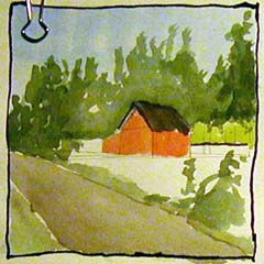
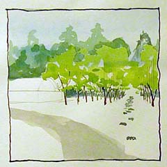
| The sequence begins with these shots from the main road. Photos from the site were studied in getting the perspective of this red building right. A sketch taken from the site photo was drawn onto a Form Z hidden line drawing. This was then used as an underlay for the watercolor. | |||||||||||
 |
 |
||||||||||
 |
|||||||||||
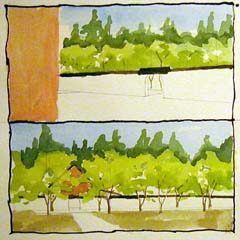
| The next portion of the sequence shows a path that takes the participant into the site. It also shows different extents and uses for the actual presentation.
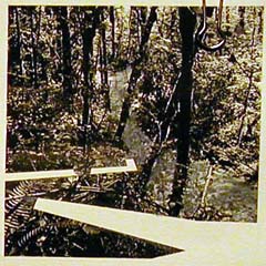
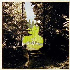
The upper left image Shows the path cut away to allow for a rendered stone path that meets up with a path that was done in Form Z. This path was printed onto a clear adhesive film and then positioned onto a digital photograph printed out. The next image, showing a woman on the path is made of different parts and then composed in Photoshop. The image is a digital photograph, the path is from Form Z and the woman is from a different photograph. To the left, the site photo was copied onto a clear adhesive paper. The Form Z model was used to cut the right stripe from this image to suggest a path that weaves down the hill out to a road. |
|||||||||||
 |
 |
||||||||||
 |
|||||||||||
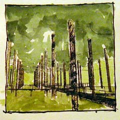
| Another model is used to show a grid of trees and the adjoining building that one approaches from the main road. The photograph is literally used in the upper left and it is used only in creating an underlay for the image at the right. The forested view to the left is a printout that has been transferred using a blender pen. The image is printed out in reverse on a laser printer and placed upside down on the paper. Applying the blender to the reverse causes the toner from the printout to mark the paper, and the marks are used then to create a quick watercolor. | |||||||||||
| The walk through is a good idea for showing the extents and spacial relationships of your site. The variety of methods here should give a few starting points for media ideas. | |||||||||||
| In the end, the hope is that this method may cause you to look at issues that putting your particular intervention raises. Does the scale look good? Does it integrate well with the landscape or is it intrusive? | |||||||||||