| PPPM 410/510 |
|
[Home | Overview | Syllabus | Schedule | Links]
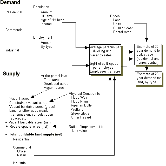
Components of a Land Needs Assessment
Source: ECONorthwest, Corvallis Buildable Lands Analysis, 1998
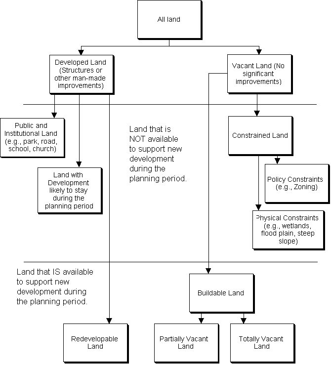
Classification scheme for urban land
Source: ECONorthwest, Corvallis Buildable Lands Analysis, 1998
Buildable Lands Definition
According to ORS 197.295,
- "Buildable lands" means lands in urban and urbanizable areas that are suitable, available and necessary for residential uses. "Buildable lands" includes both vacant land and developed land likelyto be redeveloped.
Gross and Net Vacant Acres
- A Gross Vacant Acre is an acre of vacant land before land has been dedicated for public right-of-way, private streets, or public utility easements. For example, a standard assumption is that about 20% of land in a subdivision is used for streets and utilities: if so, then a gross vacant acre will yield only about 35,000 sq. ft. (80% of a full acre) for lots.
- A Net Vacant Acre is an acre of vacant land after land has been dedicated for public right-of-way, private streets, or utility easements. A net vacant acre has 43,560 square feet available for construction, because no further street or utility dedications are required: all the land is in lots.
Definitions
Land must be classified into a series of mutually exclusive categories. Most land needs analyses provide a series of definitions. These definitions change depending on the community. The following examples are from the Corvallis buildable lands analysis. Note, however, that definitions need to be customized depending on city policies and other considerations.
Each parcel should be assigned to one of the following land use categories:
- Vacant Land: Vacant Land means all parcels greater than 0.075 acre (3,250 sq. ft ) with improvement value < $5,000.
- Partially Vacant (Under-Utilized) Land: Partially Vacant Land means all parcels greater than 0.075 acre (3,250 sq. ft ) with improvement value > $5,000 that have a developable remainder.
- Constrained Land: Constrained Land is subtracted from Total and Partially Vacant Land to get Buildable Land (which is further divided into totally vacant and partially vacant based on parcel boundaries and existing development on parcels). There are several categories of constraints:
- Wetlands
- Floodplain
- Drainageways
- Hazardous Land: Slide Areas, Steep Slopes, and Earthquake Faults
- Lands Above Third Level Water Service (560' in Elevation)
- Parks/Open Space: No development potential is expected on existing park and open space lands within the UGB.
- Institutional Use: Most publicly owned parcels are parks, governmental, or public facilities and are considered unavailable for development.
- Redevelopable Land: Redevelopment potential deals with parcels with developed structures that are likely to be demolished for new buildings to be constructed in their place. Redevelopable Land means all commercial, multi-family residential, or industrial parcels, that are greater than 0.1 acres and have land values greater than improvement values and are not already classified as vacant or partially vacant.
Conducting the Housing Needs Assessment
The basic steps in the process as described in the HB 2709 Workbook are to:
- Project the number of new housing units needed in the next 20 years.
- Identify relevant national, state, and local demographic and economic trends and factors that will affect the 20-year projection of structure type mix.
- Describe demographic characteristics of the population and, if possible, household trends that relate to demand for different types of housing (e.g., household income, household size, age of household head, percent of income paid for housing and tenure).
- Determine the types of housing that are likely to be affordable to the projected households, based on household income, household size, age of household head, tenure data and trends, and knowledge about national, state, and location housing trends, and local housing policies.
- Estimate the number of additional needed units by structure type.
- Determine the needed density ranges for each plan designation and the average needed net density for all structure types.
Calculating Residential Land Need
The basic steps in the calculations are:
Added population during planning period
–quarters Persons in group
= Persons in householdsPersons in households
÷ Average household size
= Needed occupied dwelling unitsNeeded occupied dwelling units
x Vacancy rate
= Needed total dwelling unitsNeeded total dwelling units
÷ average residential density
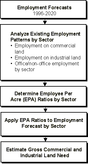
= needed acresCalculating Non-Residential Land Need
[Home | Overview | Syllabus | Schedule | Links]
This page maintained by Bob Parker, ©2000
March 25, 2000