Map Patterns of Low-Angle faults
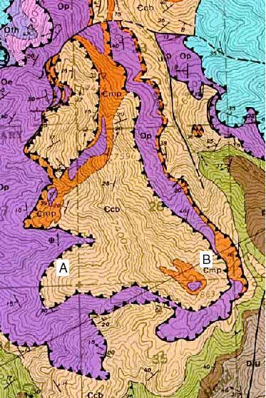 Part of the
Yost Quadrangle, north western Utah. Although the faults in this example
are not horizontal like the bedding shown in the other examples, we can
see that they dip at low angles because the fault traces tend to follow
the topography. Look, for example, at the fault at points A and B. Immediately
north of A, the fault swings far into the valley to make a prominent V
that is parallel to the contour lines. At B, the fault wraps around a hilltop.
Note also, however, that the fault can't be horizontal, as its trace lies
at a higher elevation at B than at A.
Part of the
Yost Quadrangle, north western Utah. Although the faults in this example
are not horizontal like the bedding shown in the other examples, we can
see that they dip at low angles because the fault traces tend to follow
the topography. Look, for example, at the fault at points A and B. Immediately
north of A, the fault swings far into the valley to make a prominent V
that is parallel to the contour lines. At B, the fault wraps around a hilltop.
Note also, however, that the fault can't be horizontal, as its trace lies
at a higher elevation at B than at A.
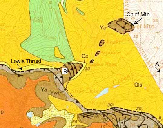
Lewis Thrust, Montana
This map above shows the Lewis Thrust in northern Glacier National
Park, MT. The Lewis Thrust must be nearly horizontal at Chief Mountain
because it wraps entirely around the mountain. This type of feature is
called a klippe--a piece of the hangingwall that is stranded from the rest
of the fault by erosion. Notice that there are three smaller klippen to
the south-southwest of Chief Mountain. To see photographs of Chief Mountain,
taken from locations A and B on the map, click here.
Return to Map Patterns