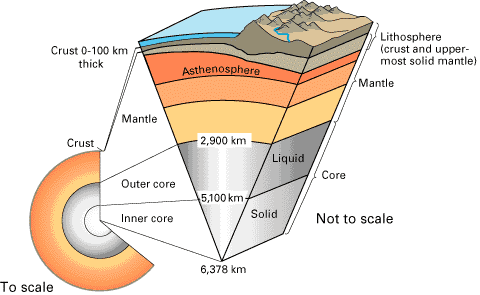
Earth's cross section. Figure source: http://pubs.usgs.gov/publications/text/inside.html |
| Plate Tectonics Primer | ||
|
|
||
| The Dynamic Earth: An Interpretive Discussion on Plate Tectonics |
| Overview |
| The solid Earth is a dynamic environment that is continually changing as a result of tectonic forces. These forces are responsible for creating many of the geologic features we see. They also govern active geologic events, such as mountain building, large earthquakes and explosive volcanic eruptions. Some geologic processes, such as volcanic eruptions or earthquakes, are so forceful they can destroy a town within minutes. Scientists study active tectonic processes for many reasons, ranging from predicting and mitigation of geologic hazards to improving our understanding of the forces that have shaped the planet. Currently geologists are working on the theory of plate tectonics. Geologically speaking, a "plate" is a large, rigid slab of rock. The word tectonic stems from the Greek root "to build". The theory of plate tectonics states that the earth's outermost, rigid layer, the lithosphere, is fragmented into a dozen or more irregularly shaped plates that are riding atop a hotter, more mobile material, the asthenosphere. While the theory of plate tectonics is now widely accepted, it is a relatively new idea that has many aspects that continue to confuse and challenge scientists. This guide will give you a step-by-step discussion of the theories behind plate tectonics as well as the evidence for plate tectonics. It will also discuss what is thought to be the driving motion of the Earth's plate, as well as, how to understand the effects of this motion. Primary Author: Bree Burdick Contributing Authors: Peter Griffen, Bill White Edited By: Emilie Hooft-Toomey and Douglas R. Toomey |
| The Earth's Structure |
|
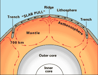
The Earth's diameter is about 12,750 kilometers. The inside of the Earth is made up of three main layers, which are the crust, mantle and core. Compared to the mantle, the crust is very thin and brittle. The thickness of the crust averages 5-100 kilometers and can be cracked (i.e. through faulting) and deformed (i.e. through folding). The mantle is located below the crust and above the core of the Earth. The mantle layer of rock is approximately 2,900 kilometers thick. Since temperature and pressure increase with depth in the Earth, the mantle is hotter, denser and is more malleable and ductile than the crust. The center of the Earth is called the core. The core is twice as dense as the mantle because it is made of metallic iron and nickel, rather than rock. The core is actually made up of two layers, one liquid layer (2,200 km thick) and a solid inner core (1,250 km). The outer core spinning at a different rate than the inner core creates the Earth's magnetic field. |
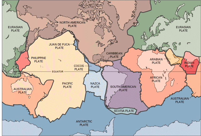
| Earth's Tectonic Plates |
|
The lithosphere is broken up into about 2 dozen or so plates, which move with respect to one and other. A tectonic plate (also called a lithospheric plate) is a massive, irregularly shaped slab of solid rock which move as cohesive, rigid bodies on the earth's surface. Tectonic plates have a large range of sizes and thicknesses. The Pacific Plate is among the largest, while the disappearing Juan De Fuca Plate is one of the smallest. Oceanic crust is much thinner than continental crust, 5 kilometers verses 100 kilometers, relatively. Oceanic crust is composed of dense, heavy basaltic rocks. In contrast, the continental crust is composed of granitic rocks, which contain relatively lightweight minerals such as quartz and feldspar. Due to the difference in density of oceanic plates in comparison to continental plates, when they collide the heavier oceanic plate will subduct beneath the lighter continental plate. |
| The Theory of Plate Tectonics |
| Introduction |
|
Beginning in the 1950's, new geophysical evidence began to influence the scientific community, resulting in the theory of plate tectonics. This theory was largely developed to explain four new and startling observations: (1) the ruggedness and youth of the ocean floor; (2) the proof of repeated reversals of the Earth's magnetic field in the geologic past and the discovery of magnetic stripes on the seafloor; (3) the development of the seafloor- spreading hypothesis; (4) the discovery that the oceanic trenches and submarine mountain ranges are zones of marked seismic activity. We will briefly discuss each aspect of the theory of plate tectonics. |
| (1) The Ocean Floor |
|
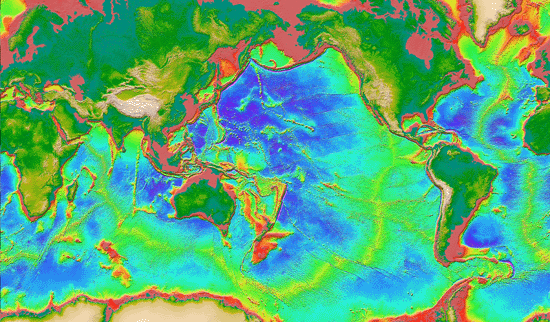
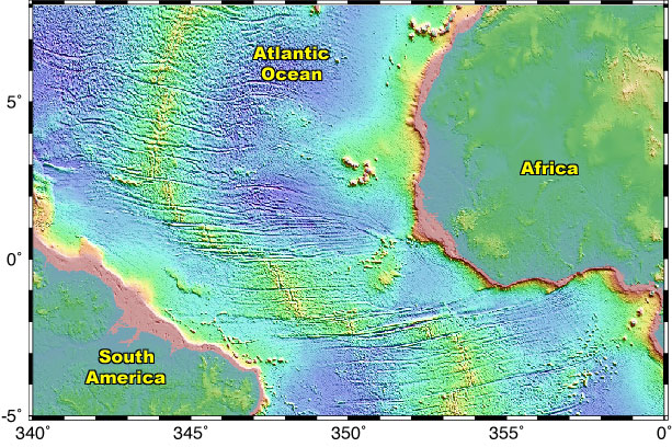
As yet, only a small amount of the ocean floors have been mapped. Although two thirds of the Earth's surface lies beneath the oceans, proper mapping instruments had not been readily available until recently. In fact, until the mid 1900's Navy ships did the only mapping using echo-sounding devices, while in route from place to place. One of the first discoveries made by the Navy's echo-sounding extensive devices was the evidence of underwater mountains. A group of these mountains were found, for example, in the Atlantic Ocean and later named the Mid-Atlantic Ridge. Due to modern tools and dedicated marine geologists, we now know that the ocean floors are more dynamic and rugged than previously thought. Marine geology research began in the 1950's and was conducted by multiple nations, led to the discovery of a great mountain chain that virtually wraps around the Earth. This global mountain range is called the "global mid-ocean ridge". This ridge, which zig-zags in between continents is of enormous height so that, by comparison, it towers over all mountains in the United States, with exception of Mount McKinley in Alaska (6,194 m). This ridge, albeit underwater, is the most prominent topographic feature on our planet. |
| (2) Magnetic Striping and Polar Reversals |
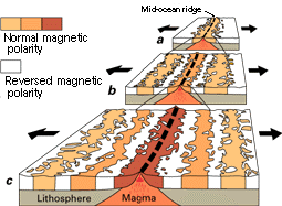
|
Research for magnetic striping and polar reversals began after World War II, when scientists, using magnetometers, towed behind ships began to recognize odd magnetic variations on the ocean floor. Although this was the first time data of this sort had been recorded, it was not totally surprising. The ocean floor is made up of an iron-rich, volcanic rock called Basalt. Within this rock is a strongly magnetic mineral called Magnetite, which has been know to locally distort compass readings. As more maps were made, scientists revealed a zebra-like pattern on the ocean floor of rocks with either normal or reversed magnetic polarity. As the Basalt flows out of a mid-ocean ridge to form new ocean floor, the magnetite within the Basalt behaves like little magnets that during cooling align themselves in the direction of the Earth's magnetic field and become solidified this way. Normal polarity is defined as the magnetic minerals in the rock having the same polarity as the Earth's present magnetic field (i.e. the north end of the rock's "compass needle" is pointing in the same direction as Earth's current magnetic north). In contrast, reversed polarity is defined as the magnetic minerals in the rock having opposite polarity to the Earth's present magnetic field (i.e. the north end of the rock's "compass needle" is pointing south). The zebra-like pattern is the result of the normal and reversed polarities formed one after one another during sea-floor spreading. Scientists do not fully understand how the Earth's magnetic field switches polarity. |
| (3) Seafloor Spreading and the Recycling of Oceanic Crust |
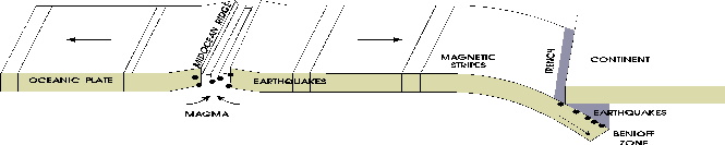
|
The observation of symmetrical magnetic stripes on the seafloor led to the development of the seafloor spreading hypothesis. Starting in 1961, seafloor spreading was hypothesized to explain these remarkable magnetic stripes that are symmetrical about the mid- ocean ridges. Mid-ocean ridges are structurally weak zones in the ocean floor, and where magma rises to form new oceanic crust. This process, called seafloor spreading, has built the present system of mid-ocean ridges. Seafloor spreading is supported by several pieces of evidence: (1) starting from the ridge and moving outward in both directions, the oceanic crust progressively gets older as the rocks move away; (2) the youngest rocks, located at the ridge crest, have present day normal polarity; and (3) each individual zebra-like strip has alternated magnetic polarity (i.e. normal-reversed-normal), suggesting that the Earth's magnetic field has reversed many times. Two geologists, Harry H. Hess and Robert S. Dietz, who first made up the term "seafloor spreading", were especially interested in the implications of the phenomenon. For the earth to produce new oceanic crust in a conveyor belt-like motion, it must shrink elsewhere for it not to expand. This takes place at ocean trenches which are very deep canyons, like along the rim of the Pacific Ocean basin. Subduction zones are plate boundaries where old oceanic crust is recycled back into the mantle. This explains why the Earth's circumference does not expand with the production of new oceanic crust and why, in comparison to continents, the seafloor has very little accumulation of sediment. Lastly, the recycling of the oceanic crust through subduction zones and the production of new crust from the mid-ocean ridges, explain why the seafloor is much younger than the continents. |
| (4) Global Seismicity Map |
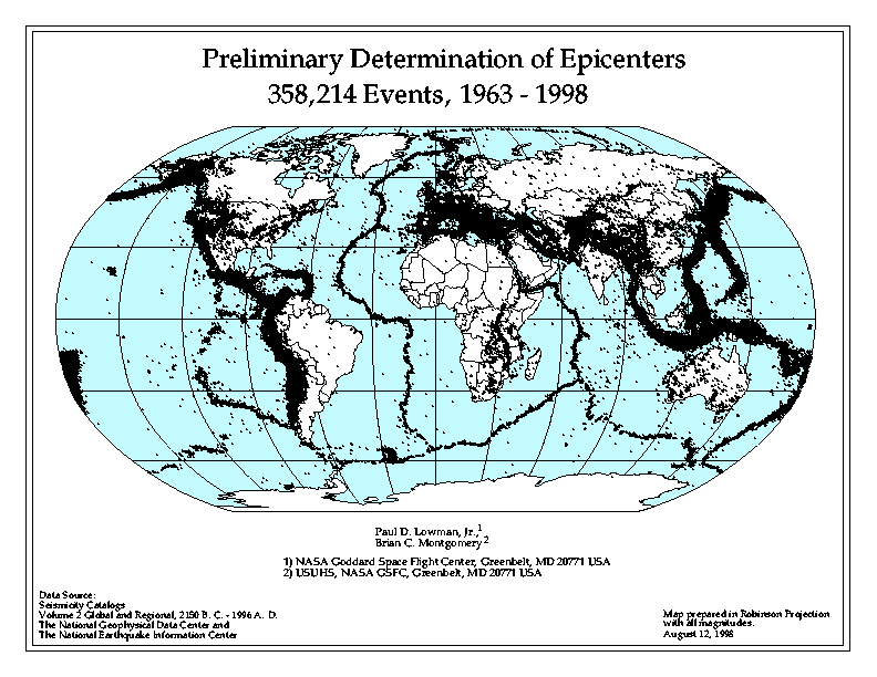
|
Through the modernization of seismic instruments, scientists learned that the majority of earthquakes are concentrated along the oceanic trenches and spreading ridges. By the 1920's, seismologists located prominent earthquake zones at oceanic trenches inclined 40-60 degrees from horizontal and extending several hundred kilometers in to the earth. These seismic zones helped confirm Hess' seafloor-spreading hypothesis by locating the places where oceanic crust is generated (along the ridges) and where oceanic lithosphere is subducted into the mantle (at the trenches). |
| Tectonic Plate Motion |
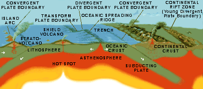
|
There are three types of motions between the tectonic plates: divergence, convergence, and lateral. The Galapagos contains three types of plate boundaries. Divergent and transform plate boundaries are located within the archipelago, while a convergent boundary exists directly off the coast of Ecuador. Divergent Boundaries occur where two plates move apart and new crust is formed from magma generated in the mantle below. Younger rocks are located at the boundary whereas the older rocks move farther and farther away. Divergent boundaries are also known as spreading centers and generate an underwater mountain chain which encircles the earth much like the seams of a baseball. Spreading centers also rift apart continents, allowing oceans to form between them. For example, the Mid-Atlantic Ridge is the focus of rifting that seperated North and South America from Europe and Africa and formed the Atlantic ocean. Oceanic-continent convergent boundaries occur when the dense oceanic crust approaches the buoyant continent and the ocean crust sinks below the continent. At an estimated depth of 100 km the crust melts and rises as magma, forming strata volcanoes on the surface directly above. This process is known as subduction and deep trenches are created by this process. Great amounts of stress are produced along these boundaries and build up over time, producing some of the world's most intense earthquakes. Oceanic-oceanic convergence involves similar processes. With the collision of two oceanic plates, subduction still occurs. Magma created by the melting crust rises to the surface creating chains of volcanoes, known as island arcs. A well-noted example of an island arc is the Alleutian Islands. Continental-continental convergence produces different results. When two continental plates converge, collision occurs. The continent buckles, squeezes, folds, thrusts, and deforms. Large-scale mountain building results from the intense collision. The Himalayan mountain range is the most recognized continent-continent collision. Transform boundaries occur where two plates slide past each other horizontally. These boundaries are usually faults that offset and connect spreading centers. Many transform boundaries are found on the ocean floors, the San Andreas Fault in California is the most recognized transform boundary located on land. Large earthquakes occur along these boundaries as the plates grind by each other. |
| Forces that Drive Tectonic Plate Motion |
|
The motion of tectonic plates, together with the flow of the underlying asthenosphere, is part of a system of convection that is the principal way in which the Earth looses heat. (Part of this heat is produced by decay of radioactive elements within the Earth, the other part is left over from formation of the Earth, 4.5 billion years ago). A series of convection cells circulate by the slow movement of the hot, softened mantle that lies below the lithosphere, in turn pushing and pulling the plates in a conveyor belt-like motion. This idea was first considered in the 1930's by an English geologist named Arthur Holmes. Nonetheless, at that time it was thought that the Earth was solid and motionless and these ideas were generally accepted until the advent of plate tectonics in the 1960's. |
| The Galapagos Mantle Plume |
|
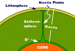
Like many oceanic islands, such as Hawaii, the Azores, and Reunion, the Galapagos are thought to be the product of a mantle plume. Mantle plumes are columns of hot rock, roughly 100 km in diameter, that rise from deep within the Earth. These plumes rise because they are hotter (by perhaps as much as 200 degrees centigrade) and therefore less dense, than the surrounding rock. The rate of ascent is about 10 cm/year. The depth from which mantle plumes rise is, however, still a matter of scientific debate; some believe that plumes originate at a shallower depth, such as the boundary between the upper and lower mantle at 670 km, others believe they come from greater depth. One idea is that mantle plumes form at the base of the Earth's mantle, at a depth of 2,900 km, where a layer of rock called D'' (D-double prime) is heated by the Earth's liquid iron core beneath it. One reason scientists believe that mantle plumes come from great depth is that they remain fixed relative to one and other over many tens of millions of years, even though the lithospheric plates above them move thousands of kilometers in this time. Thus the distance between the active Galapagos and Hawaiian volcanoes has remained fixed, even though the volcanos are carried off in opposite directions by lithospheric motion. |
| Magma Generation and Volcanism |
|
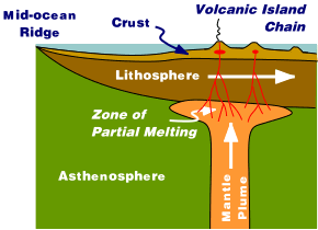
As plumes near the surface, they begin to melt. The melting occurs as a result of decompression (the decrease in pressure experienced by the plume as it rises) rather than any heating. Melting probably begins at a depth of 150 km or so and continues until the plume is prevented from further rise by the overlying lithosphere. Lithosphere is the relatively cool and rigid outer layer of the Earth that extends to depths as great as 100 km beneath oceans and 200 km beneath continents. Lithosphere forms as the underlying asthenosphere, which, though solid, is hot enough to flow, cools. The lithosphere beneath the Galapagos is relatively young, and therefore thin, perhaps no more than 15 km or so thick. Thus the region of melting beneath the Galapagos probably extends from depths of 100 or 150 km to 15 km. The temperature at these depths is 1400° C and more. By the time the melts reach the surface, however, they have cooled to 1100-1200° C. The plume does not melt completely. At a maximum, only about 20 percent of so of it melts. The melt, or magma, is initially present as microscopic channels wetting the surface between mineral grains. Because it is less dense than the surrounding rock, however, it quickly aggregates and and begins to rise to the surface. Rising into the lithosphere, it eventually becomes trapped in large pools, called magma chambers at depths between a few kilometers and ten kilometers beneath the surface. Occasionally, the magma in the chamber is able to force its way to the surface, producing a volcanic eruption. Successive eruptions over hundreds of thousands and years produce a volcano. Some of the magma crystallizes within the magma chamber, thickening the crust beneath the volcano. |
| Plate Migration Across Mantle Plumes |
|
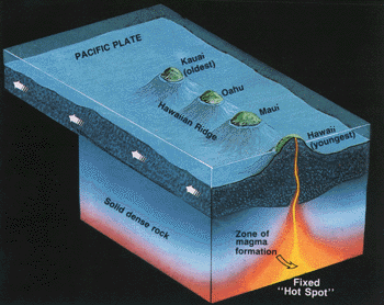
As a lithospheric plate moves over a mantle plume, a chain of volcanoes is created. The volcanoes get older in the direction of plate motion. The Hawaiian mantle plume has created a chain of volcanic islands and seamounts (known as the Hawaiian-Emperor chain) thousands of kilometers long over the past 80 million years. The Hawaiian mantle plume is located beneath the Pacific plate, which is moving to the west-north-west, hence the Hawaiian Islands get older to the west-north-west. Motion of the lithosphere eventually carries a volcano away from the plume and its magma source, so the volcano then becomes extinct. Volcano formation from the fixed mantle plume traces a path of the migrating lithospheric plate. |
| Emergence and Submergence of the Galapagos Islands |
| Josh's Figure |
The formation of an oceanic island starts with the thermal expansion of the seafloor. Then as the heat source becomes more active, magma will intrude into the crust and eventually lava will be erupted onto the seafloor. Volcanoes take a long time to appear above sea-level, for every 1 km of elevation growth, 4 km of sinking occurs, forming a big root with in the lithosphere. Volcanoes grow internally, as well as externally, by intruding magma into the base of the volcano. In fact, it is believed that only 20% of the volcanoes molten material is ever emitted as lava (Crisp, 1984). Motion of the lithosphere eventually carries a volcano away from the plume and its magma source, so the volcano then becomes extinct. The volcano and the lithosphere beneath it then begin to cool. As it cools it contracts. As a result of this contraction, the volcano slowly sinks beneath the sea. Also, the oceanic lithosphere will start to sag due to the weight of the volcanic island, submerging the volcano even further. The youngest Hawaiian volcanoes are islands, but the older ones are now seamounts, the tops of which become progressively deeper to the northwest. Likewise, many of the Galapagos seamounts were once islands. Because the Carnegie and Cocos Ridges disappear into subduction zones, it is uncertain how old the Galapagos mantle plume is. A 1990 oceanographic expedition, however, did locate an 8 million year old seamount on the Carnegie Ridge that was certainly once an island. This volcano, though now 1500 m beneath sealevel, has rounded cobbles on a flat top, which provide clear evidence of wave erosion. Thus there have been islands in the Galapagos for at least 8 million years. The plume, however, is certainly even older. Many scientists believe that the Galapagos mantle plume is responsible for the abundant volcanic rocks of Creteaceous age that occur in the Carribean and on the northwest margin of South America. Thus the Galapagos mantle plume could be as old as 90 million years and there may have been islands in this locality this long. |
| Bibliography |
| Galapagos Geology on the Web [http://www.geo.cornell.edu/geology/Galapagos.html] |