|
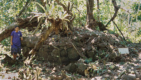
| Southeast side of tomb enclosure at Nanimwinsapw site. Ray Ladore observes the wall construction from inside the enclosure. Photo: W.S.Ayres |
In 1999, we did clearing and mapping of the major tomb in the site complex at Nanimwinsapw; this is a 15 by 20m stone walled enclosure with a central tomb platform that sits at the shoreline and extends out into the mangrove swamp.
Other training projects included additional GPS point survey locations and detailed mapping in the well-known Nan Madol site on Pohnpei's east coast. As well, we developed a plan to work with the HPO to create a comprehensive site record database. Thus, the interaction involved both collaborative archaeological research and cultural resource management.
|
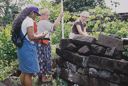
| Recording mapping data points at Nan Madol using Global Positioning System unit. Kristin Vanwert (right, University of Montana) takes notes while Lisa Andon holds the recording antenna, and Derelisa Ardos (left) reads the instrument panel screen reporting the location. Photo: W.S.Ayres |
Acknowlegements: Emensio Eperiam, Chief, Historic Preservation Office, Pohnpei State, Federated States of Micronesia, was the key administrator on Pohnpei. David Panuelo, Head of Lands and Natural Resources for Pohnpei State and Condios Cornelios, Head of the Land Surveying Office, were instrumental in providing resources for suveying and map management. Project participants included: Retty Lawrence, HPO Site Recorder and Oral Historian, Lisa Andon and Lerleen David, Maritime Museum staff, Rosenda Etse, HPO staff, Derelisa Ardos, College of Micronesia Student Trainee, and Raymond Ladore, an independent field archaeologist. Dr. Rufino Mauricio, Chief Archaeologist and Acting Historic Preservation Officer, for the Federated States of Micronesia, served as the FSM liaison.