Land and Sea
 I
had the pleasure of visiting Kapingamarangi. It took three days
of travel on the high seas to get there. We traveled by night
and made stops during each day. The stops were no longer than
six hours at the two islands along the way. Even my stay on Kapingamarangi
was no more than six hours. Still it was well worth the effort.
Others have made the trip and I find their descriptions informative:
I
had the pleasure of visiting Kapingamarangi. It took three days
of travel on the high seas to get there. We traveled by night
and made stops during each day. The stops were no longer than
six hours at the two islands along the way. Even my stay on Kapingamarangi
was no more than six hours. Still it was well worth the effort.
Others have made the trip and I find their descriptions informative:
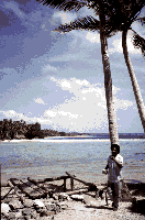
| Approaching Kapingamarangi Atoll on a ship from the north, you really have to hit 154 degrees, 46 minutes east longitude dead on. If you pass three miles east or west of it, you'll never see the place. Its first appearance from about two miles away struck me as if I was seeing a low, green hedge growing out of the ocean. The hedge gets taller as you get closer until, about a mile off, you can distinguish trees and reef. High islanders seeing it for the first time are always struck by the lack of a mountain to keep it from being washed away by the first big wave. From the first time I entered that lagoon and approached the white beaches, tall trees, and the canoe houses and crystal clear waters that line the islets' shores in 1966--and every time since--the sight of this place has never failed to take my breath away. (Lieber, 1994, p.3) |

|
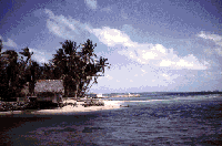
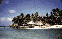
The Island of Kapingamarangi is an oval ring of coral reef, 6 to 8 miles in diameter. (See Map, Fig. 1.) The rim of this reef varies from 300 to 1300 yards in width and is a foot under water at high tide, except for the 33 sand islets a few feet above sea level which form a crescent of islets on the eastern, or windward, half of the circular reef. The land is within an area where rain squalls drench the coral soil frequently enough to support a lofty and lush vegetation of fruit-bearing trees; the coconut, breadfruit, and pandanus. In the several acres of swamp land at the center of the larger islets, taro has been planted. Wells on these larger islets supply drinkable water. A break in the southwest quadrant of the atoll ring affords a pass wide and deep enough to permit the entry of vessels of 12-foot draught. The lagoon has numerous shoals, sand banks, and coral heads, but also wide expanses of deep water. The largest of the islets, Hare, is 1.29 miles long and 500 feet wide; the smallest is about 30 yards in diameter. A reef flat connects all the islets and extends oceanward to a distance of 50 to 250 yards. The lagoon shore of most of the islets has a sandy beach ideal for launching and hauling up canoes from the adjacent shallow waters of the lagoon. It is along the sheltered lagoon beaches that the people live and carry on most of their activities. (Material Culture of Kapingamarangi, Buck 1950 p.5) |
For a more detailed depiction of the atoll please see the charts of Kapingamarangi depicting names of places, reefs and coral heads. (Appendix L: Place names, Reefs, Coral heads (Lieber, 1974: p.47,48)