Heat Flow, Mantle Convection and Plate Tectonics
A Brief History of the Plate Tectonic Theory
Early in this century, geologic thought was was dominated by beliefs
that the ocean basins were extremely old and that the geographic relationships
between continents and ocean basins were permanent. In other words, it
was thought that the present day distribution of continents and ocean basins
had existed throughout geologic time. It was recognized that the
crust of the Earth was indeed subject to powerful forces -
forces capable of uplifting entire mountain chains and of deforming or
squeezing rocks within the crust. The folding and deformation observed
was thought to be the result of contraction of the Earth caused by cooling
from the once-molten state. It was thought that after the Earth was
largely melted during the "Iron Castrophy" gradual cooling resulting in
contraction, or shrinking. This contraction caused the outer solid,
cool, "skin" of the Earth to deform by folding - much like the skin of
a fruit folds and wrinkles as the fruit dries out. In retrospect,
the scientific view of the planet during the entire first half of this
century likened the Earth to a grape transforming into a raisin.
The beginnings of the Plate Tectonic Theory began with a German Meteorologist
by the name of Alfred Wegener. He put forth in 1915 a radical proposal
that continents had drifted about the face of the Earth. His proposal
became known as Continental Drift. He hypothesized
that prior to 200 Ma. all of the continental land masses were welded into
a single "super continent" which he called Pangea (Greek meaning "all earth").
This super continent began to break up about 200 million years ago into
smaller continents which then "drifted" to their current positions.
He and a small group of others collected substantial evidence to support
this theory:
1) fit of South America and Africa
2) ancient climatic similarities, esp. polar glaciation
3) similar rock structures on either side of the Atlantic
4) fossil evidence
Wegener's book was translated into English in 1924 and was greeted
with nothing short of hostile criticism by the North American Scientific
Community. The theory of Continental drift was largely rejected because
Wegener was unable to provide a viable mechanism to drive the moving continents.
During WWII, the U.S. Navy's search for German submarines in the Atlantic
Ocean, using SONAR and sensitive magnetometers, produced a wealth of data
that would ultimately lead to conclusive proof of the dynamic nature of
the lithosphere. Based on these data, the concept of Sea Floor
Spreading became widely accepted, and this concept -- one describing
the formation of new oceanic crust at mid-ocean ridges and the subsequent
spreading of that crust -- led to the development of the theory of Plate
Tectonics.
Before examining the theory of Plate Tectonics, it is
necessary to learn about the generation and transfer of heat within the
interior, and how we measure this flow of heat.
Heat Flow
There are basically two sources of heat for the interior of the Earth:
-
Heat produced by radioactive decay of unstable isotopes
-
Heat left over following the formation and
differentiation of the Earth
The contribution of radioactive heating can be understood by reference
to the following two tables. The first shows the energy produced
per year from the decay of Uranium, Thorium and Potassium in granite, basalt
and peridotite, rocks characteristic of the continental crust, oceanic
crust and mantle respectively. From this table, it ia apparent that
differentiation resulted in the radioactive isotopes being primarily concentrated
in the continental crust. We would thus expect radioactive heat production
to be highest in the continents.
|
Rock
|
U
|
Th
|
K
|
Heat Production (ergs/gm/yr)
|
|
|
|
|
|
| Granite |
4
|
13
|
4
|
300
|
| Basalt |
0.5
|
2
|
1.5
|
50
|
| Peridotite |
0.02
|
0.06
|
0.02
|
1
|
| Iron Core |
|
|
|
much less than above
|
Although the continental crust contains a greater proportion
of heat-producing elements, the mantle is so much larger in mass that heat
production in the mantle and continental crust is almost equal.
Total Heat Produced
Heat produced = heat production by rock type x total mass
|
Region in Earth
|
Heat Production
|
|
Crust
|
3.99 x 10¹² cal/sec
|
|
Mantle
|
3.30 x 10¹² cal/sec
|
|
Core
|
much less than above
|
Total Heat Produced = 7 x 10¹² cal/sec
Heat that originally produced prior to, and during the Iron Catastrophe
is concentrated in the deep interior (lower mantle and core). For
the past 4.6Ga, this heat has been slowly transferred from the deep interior
to the surface as the Earth cools. Owing to the fact that rocks are
not good heat conductors, the primary mode of heat transfer is by
convection of the hot, plastic asthenosphere.
The transfer of heat from the interior to the surface is measured as
heat flow. On continents, heat flow is usually measured in deep drill
cores. Temperatures are measured going down the drill hole and establish
a temperature gradient. Rocks that form the drill core are them measured
for the thermal conductivity. Knowing the temperature variation with
depth and the conductivity, we can calculate the heat flow, usually expressed
in units of micro-calories/cm2 /sec.
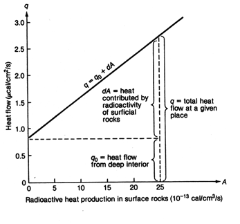 It turns out that
it is possible to separate the effects of radiogenic heat production in
the crust from flow of heat coming from the mantle. The figure to
the left illustrates how this can be done (for more details see p. 371
of your textbook). For a given section of crust, heat flow from the
mantle is a constant, whereas heat produced by radioactive decay depends
on the composition of the crust (i.e., how much radioactive isotopes are
present. If we measure the heat flow, and can determine how much
heat is produced in the underlying crustal rocks (by knowing their radioactive-isotope
content), a linear relationship results. THe constant in the linear
equation is the heat flowing from the mantle into the base of the crust.
It turns out that
it is possible to separate the effects of radiogenic heat production in
the crust from flow of heat coming from the mantle. The figure to
the left illustrates how this can be done (for more details see p. 371
of your textbook). For a given section of crust, heat flow from the
mantle is a constant, whereas heat produced by radioactive decay depends
on the composition of the crust (i.e., how much radioactive isotopes are
present. If we measure the heat flow, and can determine how much
heat is produced in the underlying crustal rocks (by knowing their radioactive-isotope
content), a linear relationship results. THe constant in the linear
equation is the heat flowing from the mantle into the base of the crust.
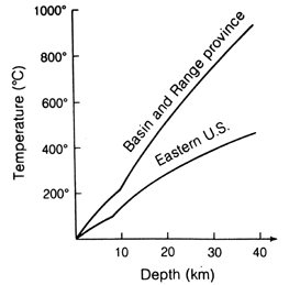 Heat flow,
and calculated geothermal gradients vary greatly from place to place.
The figure to the left illustrates the calculated geothermal gradients
for the eastern U.S. and the Basin and Range Province in the western U.S.
Note that at 35 km depth (the "normal" depth of the MOHO beneath continents,
the Basin and Range is roughly twice as hot as is the eastern part of the
continent. The "hot" character of the Basin and Range Province coincides
with its geologic and tectonic activity ( it is young and hot). Furthermore
the high heat flow values cannot be entirely explained by heat production
in the crust. The mantle beneath this region must also be hotter
than normal. In contrast the eastern U.S. consists of old and
cold crust, lithosphere and asthenosphere.
Heat flow,
and calculated geothermal gradients vary greatly from place to place.
The figure to the left illustrates the calculated geothermal gradients
for the eastern U.S. and the Basin and Range Province in the western U.S.
Note that at 35 km depth (the "normal" depth of the MOHO beneath continents,
the Basin and Range is roughly twice as hot as is the eastern part of the
continent. The "hot" character of the Basin and Range Province coincides
with its geologic and tectonic activity ( it is young and hot). Furthermore
the high heat flow values cannot be entirely explained by heat production
in the crust. The mantle beneath this region must also be hotter
than normal. In contrast the eastern U.S. consists of old and
cold crust, lithosphere and asthenosphere.
Heat flow in the ocean basins is also highly variable. The highest
values correspond to the mid-ocean ridges. Heat flow decreases away
from the mid-ocean ridges and is at a minimum over the convergent plate
boundaries, deep ocean trenches or subduction zones. In general
lithosphere is hot where the underlying asthenosphere is hot, and cold
here it is cold. This observation strongly supports the concept that
plate tectonics is largely driven by convection within the asthenosphere.
Sites characterized by upwelling of hot asthenosphere (the rising limbs
of convection cells) have high heat flow (e.g., mid-ocean ridges).
In contrast areas where the convection cells turn and sink back into the
deep interior are cold (e.g., subduction zones).
Plate Tectonics
At present, the Earth's lithosphere can be divided into 14 - 16 recognized
plates, each moving at different velocities and in relatively different
motions. The 14 major plates are shown in the following figure:
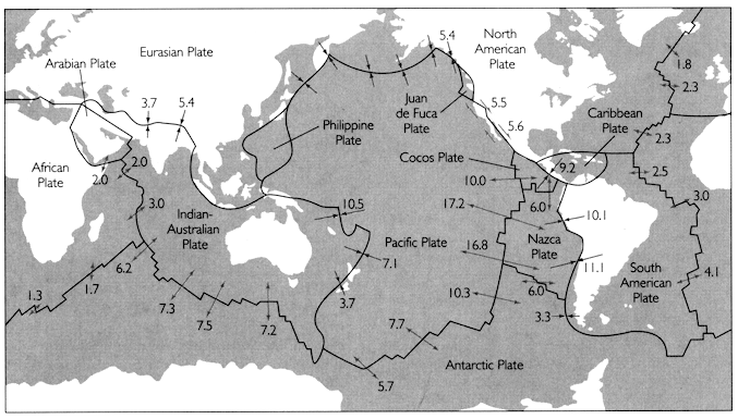
The figure above, not only identifies the individual plates but
also gives their realtive movement and velocities (in cm/yr of either convergence
or divergence).
Lithospheric plates are defiend on the basis of their boundaries.
These boundaries are large-scale major fault boundaries. As
such they are easily recognized by the fact that many earthquakes occur
along the boundaries. The boundaries associated with mid-ocean ridges
(divergent boundaries) are characterized by frequent, shallow and low-magnitude
earthquakes. Convergent boundaries (typically subduction zones) are
characterized by earthquakes that are shallow near the intersection of
the boundary with the surface, but increase with depth in the direction
of convergence. This increase in depth of earthquakes defines the
dipping slab of lithosphere descending into the mantle (the Benioff zone).
Plate boundaries are classified as follows (Please refer to your text
and lecture notes for further details of each type of boundary):
I. Divergent Boundaries
A. Oceanic (e.g., mid-ocean ridges)
B. Continental (e.g., east-African rift)
II. Convergent Boundaries
A. Oceanic - Oceanic (e.g., Phillipine Arc)
B. Oceanic - Continental
C. Continental - Continental (e.g., Himalayas)
III. Transform Boundaries
A. In ocean basins (numerous examples)
B. On continents (relatively rare -- best example is the San Andreas
Fault)
Determining Relative Plate Motions and Velocities
Our current understanding of plate motions (directions) and velocities
comes from a combination of two sources of data:
1. Paleomagnetism
a) inclination
b) declination
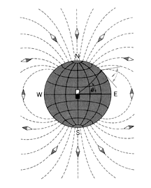 Use of paleomagnetism
to determine plate motion can be illustrated with reference to magnetic
inclination. The figure to the left (fig. 19-5 in Press and
Siever) shows the magnetic field associated with the Earth and the directions
that a compass needle will point at various latitudes. Note that
at either magnetic pole the needle will point toward the center of the
earth; at the equator it will be horizontal; and at all other latitudes
it will be inclined with the amount of inclination being determined by
the latitude.
Use of paleomagnetism
to determine plate motion can be illustrated with reference to magnetic
inclination. The figure to the left (fig. 19-5 in Press and
Siever) shows the magnetic field associated with the Earth and the directions
that a compass needle will point at various latitudes. Note that
at either magnetic pole the needle will point toward the center of the
earth; at the equator it will be horizontal; and at all other latitudes
it will be inclined with the amount of inclination being determined by
the latitude.
Igneous rocks are ideal candidates for determining the state of the
Earth's magnetic field at the time the rock crystallized and cooled.
Igneous rocks contain minor quantities of minerals that are magnetic.
When igneous rocks (e.g., lava flows) crystallize and coole below a certain
temperature (the Curie temperature), the magnetic minerals will align their
magnetic moments with the magnetic field of the Earth at that time.
Oriented specimens of igneous rocks can be collected in the field and the
magnetic properties of the rocks can be analyzed in the lab. The
resultant data include the magnetic inclination of the rock, and hence
the geographic latitude at the time the rock formed. If we can also
determine the age of formation, then we know the latitude of the rock when
it formed.
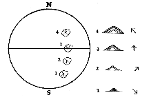 A simple example
is given in the figure to the left. Consider a volcanic island located
on a plate moving from south to north. Samples collected from 4 different
, progressively younger, lava flows on the volcano can be both dated and
their paleomagnetic inclinations determined. In this case, the oldest
flows (1&2) erupted in the southern hemisphere; flow 3 erupted at the
equator and flow 4 erupted in the northern hemisphere. Precise inclination
data combined with ages of eruption allow reconstruction of the movement
of this island (and the lithospheric plate it is sitting on) with time.
From these data, we can reconstruct the relative movement of the plate
with time (relative to the Earth's magnetic poles).
A simple example
is given in the figure to the left. Consider a volcanic island located
on a plate moving from south to north. Samples collected from 4 different
, progressively younger, lava flows on the volcano can be both dated and
their paleomagnetic inclinations determined. In this case, the oldest
flows (1&2) erupted in the southern hemisphere; flow 3 erupted at the
equator and flow 4 erupted in the northern hemisphere. Precise inclination
data combined with ages of eruption allow reconstruction of the movement
of this island (and the lithospheric plate it is sitting on) with time.
From these data, we can reconstruct the relative movement of the plate
with time (relative to the Earth's magnetic poles).
2. The tracks of Hot Spots
Hot spots are considered to represent the surface
manifestation of plumes of hot material that rise from very deep within
the mantle, drill through the lithosphere and emerge as volcanic centers
on either the sea floor or on continental crust. The source for the
plumes is apparently fixed in the lower mantle, and consequently is not
affected by movement of lithospheric plates. As a result, a hot spot
produces a linear trail of extinct, progressive older volcanoes as a plate
moves over it.
The best example of a hot spot track is the chain of oceanic volcanic
islands that include the Hawaiian islands and, extending to the NW the
Emperior Seamount chain. This spectacular example is shown below:
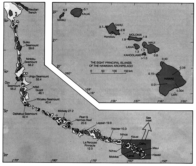
Note the prgressively decreasing age of volcanic rocks going from the
NW to the SE in both the Hawaiian Islands proper and their counterparts
to the NW, including Midway and extending all thte way to the Aleutian
Islands. This entire chain of volcanic islands formed as the Pacific
Plate passed over a hot spot. The age of volcanic rocks and their
relative position provides a recording of Pacific Plate movement and velocity
for the past 60Ma. It is also very apparent that the motion of hte
Pacific Plate made an abrupt change at approximately 40Ma (corresponding
to the "kink" in the linear trend of volcanoes).
Tracks of hot Spots have also been identified on the continents.
The best known (at least to me), is the Yellowstone Hot Spot, which marks
the path of North America over a hot spot currently located beneath Yellowstone
National Park. Relative to this hot spot, the North American Plate
has moved to the SW, producing a linear trend of volcanism defining the
Snake River Plain.
Hot spots and deep mantle plumes are currently hot topics (pun intended)
for research in geology, and this research promises to give us a better
understanding of the workings of not only plate tectonics, but also of
the deep mantle.
 This page created by Jack Rice with Netscape Navigator Gold